
Major Hurricane Erin expected to bring serious threats of flooding and erosion to Outer Banks
- Corinne Saunders

- Aug 18, 2025
- 4 min read
Updated: Aug 20, 2025
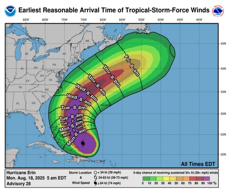
As of Monday, Aug. 18, 2025, the projected path for Hurricane Erin remains offshore, with the greatest impacts expected along the Outer Banks. (Image courtesy the National Weather Service)
By Corinne Saunders
Dare and Hyde counties each issued a state of emergency declaration Sunday evening and mandatory evacuation orders for Hatteras Island and Ocracoke Island as potentially dangerous conditions from Hurricane Erin are expected to begin Tuesday.
Hurricane Erin, currently a Category 4 storm with maximum sustained winds of 130 mph, is expected to stay offshore. But the U.S. National Weather Service at Newport/Morehead City on Monday morning predicted an increased chance of “life-threatening rip currents, damaging beach erosion, major coastal flooding and overwash and extremely dangerous surf.”
Coastal flooding and ocean overwash, especially around high tide, could be a “long duration issue” and could begin as early as Tuesday, peaking Wednesday into Thursday, according to Monday’s hurricane briefing.
“Strong long period wave energy” with waves of 15 to over 20 feet in the surf zone could cause “extensive beach erosion,” and portions of N.C. Highway 12 on the Outer Banks may be impassable for several days, the briefing stated.
Dare County on Sunday around 5:30 p.m. issued a mandatory evacuation for Hatteras Island (Zone A), which is the entire island, including the unincorporated villages of Rodanthe, Waves, Salvo, Avon, Buxton, Frisco and Hatteras. Visitors must evacuate beginning at 10 a.m. on Monday, and residents must evacuate beginning at 8 a.m. on Tuesday.
Hyde County’s mandatory evacuation order for Ocracoke Island, issued Sunday evening, was immediately effective for visitors, with their evacuation beginning at 8 p.m. Ocracoke Island residents must evacuate starting at 6 a.m. on Tuesday.
“Please take this warning seriously, especially if you have medical issues or are likely to need special care,” the Hyde County press release announcing the order said.
Hyde County Emergency Medical Services will likely not available as N.C. Highway 12 is expected to be inaccessible, according to the press release.
“Dangerous waves, 20+ feet, will likely inundate and destroy protective dune structures along the highway,” the release said.
The North Carolina Department of Transportation Ferry Division announced Monday around 7:30 a.m. that it was suspending Hatteras-Ocracoke ferry operations due to the mandatory evacuation of Ocracoke Island.

The entire Outer Banks area is at a high risk of flooding impacts from Hurricane Erin. (Image courtesy National Weather Service)
Both Hyde and Dare counties’ respective public information warned people to stay out of the Atlantic Ocean.
When double red flags are posted by ocean rescue agencies, no one may enter the water in Dare County except for surfers using a surfboard and a leash, the Sunday evening Dare County release said. The most dangerous ocean conditions are expected Wednesday and Thursday, but life-threatening rip currents are expected for most of the week.
The Dare County Department of Health & Human Services’ Social Services Division maintains a Special Medical Needs Registry, the press release said. Anyone who has or who knows someone with special medical needs who may need assistance during an emergency or evacuation can call 252-475-5500 to register.
The storm is expected to increase in size, with tropical storm force winds predicted to reach the coast, especially the Outer Banks.
The National Hurricane Center shared around 8:30 a.m. Monday that Hurricane Erin is located just over 100 miles north-northeast of Grand Turk Island. Its projected path takes it northwest, then north through midweek.

A crew filming “Good Morning America” goes live at 7 a.m. at a Kill Devil Hills beach access on Monday, Aug. 18, 2025. Victor Oquendo (center), a Florida-based ABC News correspondent, talks about the forecast of strong rip currents and large waves along the Outer Banks. (Photo by Corinne Saunders)
School updates
College of The Albemarle (COA) announced it would delay the start of its fall 2025 semester from Monday until at least Wednesday due to the state of emergency issued for Dare County because of anticipated impacts from Hurricane Erin.
All COA campuses—Elizabeth City, Currituck, Dare and Edenton-Chowan—are closed Monday through at least Wednesday, with only essential personnel expected to report if possible, the college announced on Sunday evening.
“While some COA locations may not feel the storm’s direct impact, many of our students, faculty and staff travel between all four locations,” the college said. “Our decision reflects the need to keep the entire COA community safe.”
Dare County Schools announced that Monday would be an optional teacher workday for Cape Hatteras Elementary School and Cape Hatteras Secondary School teachers, and that staff should contact their building principal or supervisor.
Dare Early College students would have a remote learning day Monday, and dually enrolled COA students would not have class, the Dare County Schools announcement said. Monday remained a required workday for school system employees north of Oregon Inlet.
Further details
The U.S. National Weather Service at Newport/Morehead City will provide twice-daily hurricane updates through Thursday. For the most current local weather information for Dare County and south, visit its website or Facebook page.
The U.S. National Weather Service at Wakefield, Virginia, covers Currituck County, including Corolla, and north. For more information about that area, visit its website or Facebook page.
The National Hurricane Center website is https://www.nhc.noaa.gov.
To sign up for Dare County-specific severe weather updates and for any other official messaging of interest, visit the OBX Alerts website.
--------
Editor’s Note: Did you appreciate Outer Banks Insider’s ad-free local news? Subscribe today at this link to access all our in-depth, exclusive reporting and to sustain community focused independent news in the area you love.


Comments